You are here
Location
Ethiopia
Ethiopia
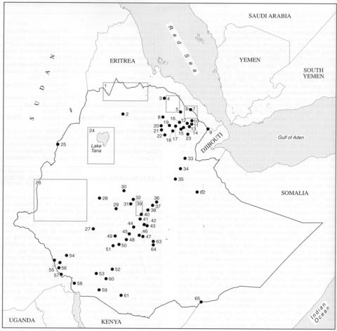
The fullest general account of the geology of Ethiopia is the three volume work of Dainelli (1943) but Mohr's (1962a) description takes account of much later work. The country can be divided into four distinct geological areas namely, the Afar Depression, the Main Ethiopian Rift and the northwest and southeast plateaux. The Afar Depression (Triangle), which extends northwards and eastwards into Eritrea and Djibouti, is the heavily faulted area in which the East African Rift system forms a junction with the rifts of the Red Sea and Gulf of Aden. Afar consists overwhelmingly of volcanic rocks including plateau lavas, which are mainly tholeiitic, and numerous central volcanoes of varying degrees of alkalinity such as the Erta Ale Range in the Danakil Depression. Because of the essential continuity of the volcanic rocks in Afar and because a high proportion are not alkaline yet intimately involved with alkaline rocks, difficulty has been found in writing the present accounts. However, the 1:2,000,000 geological map of Merla et al. (1979) and the very detailed maps of Varet (1978) for central and southern Afar and Barberi et al. (1973b) for northern Afar have enabled the main occurrences involving alkaline rocks to be delimited. A general account of the volcanism of Afar and its relationship to tectonics is that of Barberi et al. (1972b). The Main Ethiopian Rift extends southwestwards from Afar and is a focus for numerous volcanoes many containing alkaline, particularly peralkaline silica oversaturated, rocks. The volcanoes of the rift are depicted on a map in Di Paola (1973). The Main Ethiopian Rift does not align exactly with the Gregory Rift, to the south in Kenya, but the Gregory Rift continues into southern Ethiopia north of Lake Turkana and is again intimately associated with voluminous volcanic rocks. Apart from the small Korath Range, however, there is little detailed information on these rocks. A useful review of the rift structure and its relationship to magmatism is that of Brotzu et al. (1986), while Berhe et al. (1987) put the igneous activity in a structural and geochronological context.
Volcanoes are also scattered over the northwestern and southeastern plateaux areas of Ethiopia, notably in a line running westwards from the Main Ethiopian Rift in the vicinity of Addis Ababa and in the area between the Tana Rift and the Afar depression. There are, however, enormous areas of plateau volcanics that erupted mainly from fissures and these cover more than half the country. Most of the plateau volcanic rocks, called the 'Trap series' in earlier papers, are not alkaline; they have been described notably by Zanettin and co-workers (e.g. Zanettin et al., 1980 and papers cited therein). Alkaline rocks are more abundant in the central volcanoes but detailed accounts of all of these have not been found. Mohr (1970) has compiled 322 rock analyses, and includes brief petrographic notes. A comprehensive report on the geothermal resources of Ethiopia covers many of the localities included in this account (Lloyd, 1973). This report also includes a useful annex on Ethiopian place names and their variants.
There is currently no additional content associated with this term.

