stripes
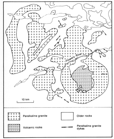
An area of peralkaline granite southwest of Flowers Bay has been described by Collerson (1982) and a similar complex of peralkaline granites around the Flowers River by Hill and Thomas (1983). Both clearly constitute part of a single complex but the areas illustrated on geological maps by the above authors are some way apart. The Flowers Bay granite forms a flat-lying sheet with a maximum thickness rarely exceeding 200 m. It consists of 20- 35% quartz, perthite, aegirine, sodic or sodic-calcic amphibole, which commonly rims the aegirine, aenigmatite, astrophyllite, a little annitic biotite, and accessories including fluorite, zircon, fergusonite and monazite. Analyses of rocks, including Sr isotopes, clinopyroxene, amphiboles, micas and aenigmatite are given by Collerson (1982). The peralkaline granites of the Flowers River area cover an approximately circular area of 1570 km2 and are associated with a varied suite of volcanics which is not, however, peralkaline (Hill, 1982, p. 70). The granite comprises 25-35% quartz, 55- 75% perthite, fayalite, ferrohedenbergite to aegirine, arfvedsonite and riebeckite, the latter commonly mantling the former, aenigmatite, astrophyllite, grunerite and biotite. Rock analyses and some mineralogical data will be found in Hill (1982).
COLLERSON, K.D. 1982. Geochemistry and Rb-Sr geochronology of associated Proterozoic peralkaline and subalkaline anorogenic granites from Labrador. Contributions to Mineralogy and Petrology, 81: 126-47.
HILL, J.D. 1982. Geology of the Flowers River - Notakwanon River area, Labrador. Report, Mineral Development Division, Newfoundland Department of Mines and Energy, 82-6: 1-140.
HILL, J.D. and THOMAS, A. 1983. Correlation of two Helikian peralkaline granite-volcanic centres in central Labrador. Canadian Journal of Earth Sciences, 20: 753-63.

