stripes
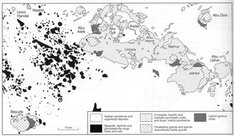
The Gilif complex, extending over an area of about 1500 km2, is the most extensive contiguous igneous complex of the Bayuda Desert, and comprises an overlapping series of ring complexes with some intercalations of basement gneiss. Morphologically the complex is expressed as the Gilif Mountains (Jubal Gilif) which in the north are separated from the basement plain by a 100-200 m high escarpment, with a summit area of 450-500 m above sea level. To the south it slopes down to a lesser escarpment and foothills of Nubian Sandstone overlain by wadi sediments. The total complex consists of a dominant extrusive facies of pisolitic and crystal tuffs and ignimbrites, which were followed by fissure eruptions of agglomerate, lava and silicified tuff. Lavas and tuffs form the summit areas of the mountains below which are hypabyssal and plutonic rocks cut by numerous dykes (Barth and Meinhold, 1979). The complex has been subdivided into a number of igneous centres, which are indicated on the map (Fig. ??). In the extreme east Abu Usher forms a complete ring structure 10 km in diameter with a summit area of silicified tuffs and peralkaline rhyolites, beneath which are bedded tuffs, peralkaline granite porphyries and rhyolitic breccias. Windows of peralkaline granite are exposed in places. The basal tuffs overlie basement biotite gneisses that are cut by swarms of dykes. South of Abu Usher is an unnamed 5x1 km intrusion composed of microsyenite and trachytic porphyries which is surrounded and intruded by basalts. Jakdul is a 15 km diameter ring structure with a superstructure, similar to that of Abu Asher, of rhyolitic extrusive rocks. A large area of peralkaline granite is exposed along the eastern margin, syenite outcrops in the northwest and to the north the complex is defined by massive ring-dykes of felsite. Namur is a further ring some 12 km across with a felsitic ring-dyke and a central area of peralkaline granite. The northern half of the complex is dominated by rhyolitic dykes, while the southern much faulted part includes areas of basement gneiss and Nubian Sandstone as well as biotite and peralkaline granite. The 25 km wide Umara intrusion is a rhyolitic vent of cauldron type formed of three major structures each forming a distinct eruption centre. The complex appears to be cut in half by the southern escarpment, but in the north is limited by a swarm of ring-dykes. Throughout the complex are peralkaline agglomerates and flows of quartz porphyry, as well as rhyolites with spherulites of riebeckite and aegirine. Peralkaline granite is exposed in two windows. The most westerly igneous centre is the ring structure of Abu Aleik. It contains a central intrusion of peralkaline syenite with some peralkaline granite surrounded by felsite ring-dykes in the north and a complex of rhyolitic and trachytic dykes. Extrusive rhyolites occur only in the southeast. The northwestern part of the Gilif complex is formed of the three igneous centres of Abu Ouk, Kalas and Abu Harot, which are essentially three shells centred on Abu Ouk and with extensive areas of basement rocks between them. Abu Ouk contains a large area of peralkaline syenite while peralkaline granite is exposed over a 10x2 km area in Kalas. The outer shell, Abu Harot, consists principally of dykes and ring-dykes with peralkaline granite in its southwestern part.
BARTH, H. and MEINHOLD, K.-D. 1979. Mineral prospecting in the Bayuda Desert. Part 1, Volume A. Investigation of mineral potential. Technical Report Sudanese-German Exploration Project. Hannover (Bundesanstalt fur Geowissenschaften und Rohstoffe). 336 pp. (unpublished) BARTH, H., BESANG, C., LENZ, H. and MEINHOLD, K.-D. 1983. Results of petrological investigations and Rb/Sr age determinations on the non-orogenic igneous ring-complexes in the Bayuda Desert, Sudan. Geologisches Jahrbuch, 51: 1-34.

