stripes
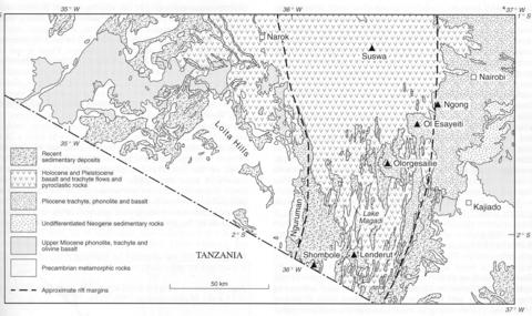
For purposes of the present description the Magadi area is taken to include the Magadi area as described by Baker (1958), the area south of Magadi, extending to the border with Tanzania (Baker, 1963b), and the easternmost part of the Loita Hills area (Saggerson, 1966). Much of the area lies within the rift valley the western wall of which is marked by the often spectacular Nguruman Escarpment. The rift valley floor is broken by numerous fault scarps that step inwards to a central trough that is partly occupied by Lake Magadi. Most of the area is underlain by volcanic rocks the Archaean basement being exposed in the upper part and west of the Nguruman Escarpment with rather less occurring to the east of the rift in the extreme south. The oldest volcanic rocks in the area, according to Baker (1958 and 1963b), are found in three central volcanoes, which are described individually, namely Olorgesailie (No. 085-00-068), Lenderut (No. 085-00-069) and Shombole (No. 085-00-070). The rift valley floor is essentially covered by ‘plateau trachytes’ underlying which are olivine basalts that only outcrop extensively along the western margin of the area and in the eastern part of the area south of Magadi. Saggerson and Williams (1964) discovered and described melanephelinite (ankaratrite) lavas in the Nguruman Escarpment which are intruded by small sills of a rock that they named ngurumanite. The lavas contain small phenocrysts of diopsidic pyroxene and olivine set in a matrix of pyroxene, ore, nepheline, olivine pseudomorphs and a striking orange biotite. The ngurumanite, of which there are several varieties, consists mainly of altered, euhedral nepheline, zoned prismatic pyroxene, opaque oxides, apatite, rare katophorite and arfvedsonite, and an abundant mesostasis of calcite and zeolites. Analyses are available in Saggerson and Williams (1964). Nephelinite and melanephelinite form a large proportion of the volcanic rocks in the northeastern corner of the Loita Hills area (Saggerson, 1966), the flows forming a succession over 250 m thick with in places agglomerates and tuffs separating individual units. Typical examples contain abundant, strongly zoned pyroxene phenocrysts up to 4 mm set in a matrix of augite and magnetite in a partly isotropic base of nepheline and analcime. Some varieties contain abundant olivine and flows of biotite-olivine melanephelinite (ankaratrite) are found at several localities. To the southwest of the area of nephelinitic flows four eroded vents have been recognised at Loisiumurto (Saggerson, 1966) that may be their source. Nephelinites also occur in the extreme southeast corner of the Loita Hills sheet that represent the most northerly products of the Oldoinyo Sambu volcano of Tanzania (see Tanzania No. 163-00-01). The plateau trachytes are lavas which contain sparse alkali feldspar phenocrysts set in a matrix of feldspar, aegirine and aegirine-augite with aenigmatite and katophorite in most rocks; quartz occurs in some samples. The plateau trachyte activity was brought to a close with the formation of a number of small ash and scoria lava cones which are all small except for the Ol Doinyo Nyegi volcano (Baker, 1958). This volcano, which rises some 300 m above the rift floor, is built of alternating feldsparphyric obsidian flows and beds of scoria and ash. The igneous activity closed with the building of a number of small ash and scoria lava vents on the trachyte plateau. Baker et al. (1977) made a detailed mineralogical and chemical study of a basalt-benmoreite-trachyte suite from the northeast of the area.
BAKER, B.H. 1958. Geology of the Magadi area. Report, Geological Survey of Kenya, 42: 1-81.BAKER, B.H. 1963b. Geology of the area south of Magadi. Report, Geological Survey of Kenya, 61: 1-27.BAKER, B.H., WILLIAMS, L.A.J., MILLER, J.A. and FITCH, F.J. 1971. Sequence and geochronology of the Kenya Rift volcanics. Tectonophysics, 11: 191-215. BAKER, B.H., GOLES, G.G., LEEMAN, W.P. and LINDSTROM, M.M. 1977. Geochemistry and petrogenesis of a basalt-benmoreite-trachyte suite from the southern part of the Gregory Rift, Kenya. Contributions to Mineralogy and Petrology, 64: 303-32. SAGGERSON, E.P. 1966. Geology of the Loita Hills area. Report, Geological Survey of Kenya, 71: 1-60.SAGGERSON, E.P. and WILLIAMS, L.A.J. 1964. Ngurumanite from southern Kenya and its bearing on the origin of rocks in the northern Tanganyika alkaline district. Journal of Petrology, 5: 40-81.

