stripes
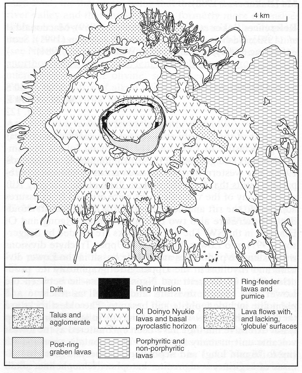
Suswa is the southernmost caldera volcano in the Kenya Rift and its products occupy much of the eastern part of the Suswa quarter degree area (No. 085-00-060). It rises from the rift floor, at a height of 1525-1615 m, to 2537 m. The products of the volcano extend over some 1000 km2. South of Suswa the rift floor is cut by parallel, north-south-trending faults into horst and trough structures but the bulk of the Suswa edifice is unaffected. The most detailed general account is that of Johnson (1969), who includes photographs and a coloured geological map, while later work is taken into consideration by Randel and Johnson (1991); Skilling (1993) studied caldera collapse at Suswa. Johnson (1969) defined three major eruptive episodes, namely (1) building of a low-angle shield volcano, (2) caldera formation and eruption of abundant pumice and thick lava flows of restricted extent and (3) filling of the caldera by lavas and the building of the Ol Doinyo Nyukie volcano, an edifice built in the southwest of the caldera around a central vent. Sodalite-bearing phonolite lavas of the early volcano lie conformably on trachytic flood lavas which cover much of the rift floor in this area. Some flows extend to 9 km from the foot of the mountain forming a fringe to the south and east, and the maximum thickness of this early shield was probably 500-600 m (Williams et al., 1984). After a period of quiescence an approximately 12x8 km caldera was formed accompanied by eruptions of pumice and lavas from ring fractures concentric to and outside the main caldera. The earliest pyroclastic rocks are a group of unsorted pumices which Johnson (1969) considered to be the products of lahars, but may have an ash flow origin (Williams et al., 1984), while later rocks include air fall and ash flow with some surge deposits, as well as lavas that extend around the caldera rim and up to 3 km down the slopes. Macdonald et al. (1993) have described in detail three thin ash flow tuffs of this group that contain pumiceous clasts, globules of trachytic glass and clasts rich in carbonate globules, in a carbonate ash matrix. Petrographic and textural evidence indicates the carbonate to be magmatic and the relationship between the trachyte and carbonate is considered to be one of liquid immiscibility. The Post-caldera lavas of the third episode comprise two groups. The earlier comprises aphyric and sparsely porphyritic phonolitic flows that partly filled the caldera and then overflowed the eastern rim to form long, thin flows. The later group are trachytes with abundant rhombic anorthoclase phenocrysts that formed the major cone of Ol Doinyo Nyukie on the southern margin of the caldera. After eruption of the last lava from Ol Doinyo Nyukie a prominent pit crater 460 m deep formed. A second major collapse then took place entirely within the main caldera to form an annular trench, or ring graben, some 5 km in diameter with a central island block. A final eruptive episode is marked by a flow in the southern part of the ring graben and a lava eruption on the outer southern flanks of the volcano; both of these are again anorthoclase-phyric trachytes. The synchronous caldera-forming events at Suswa have been investigated using tephrachronology by Scott and Skilling (1999) while incremental collapse of the caldera was studied by Skilling (1993). A detailed account of the mineralogy and petrology of the Suswa lavas is that of Nash et al. (1969) who give modal data and numerous microprobe and whole rock analyses. They demonstrate that the rocks vary from trachytes to phonolites with phenocrysts, in order of abundance, of alkali feldspar, augite, fayalitic olivine, titanomagnetite and, in one rock group, sodalite. Only in the later lavas, however, are phenocrysts abundant. Matrix phases include alkali feldspar, Fe-Ti oxides, nepheline, sodalite, augite, aenigmatite, sodic amphibole and glass.
BAKER, B.H., MITCHELL, J.G. and WILLIAMS, L.A.J. 1988. Stratigraphy, geochronology and volcano-tectonic evolution of the Kedong-Naivasha-Kinangop region, Gregory Rift valley, Kenya. Journal of the Geological Society of London, 145: 107-16.JOHNSON, R.W. 1969. Volcanic geology of Mount Suswa, Kenya. Philosophical Transactions of The Royal Society of London, 265A: 383-412.MACDONALD, R., KJARSGAARD, B.A., SKILLING, I.P., DAVIES, G.R., HAMILTON, D.L. and BLACK, S. 1993. Liquid immiscibility between trachyte and carbonate in ash flow tuffs from Kenya. Contributions to Mineralogy and Petrology, 114: 276-87.NASH, W.P., CARMICHAEL, I.S.E. and JOHNSON, R.W. 1969. The mineralogy and petrology of Mount Suswa, Kenya. Journal of Petrology, 10: 409-39.RANDEL, R.P. and JOHNSON, R.W. 1991. Geology of the Suswa area. Report, Geological Survey of Kenya, 97: 1-41. SCOTT, S.C. and SKILLING, I.P. 1999. The role of tephrachronology in recognizing synchronous caldera-forming events at the Quaternary volcanoes Longonot and Suswa, south Kenya Rift. In C.R. Firth and W.J. McGuire (eds) Volcanoes in the Quaternary. 47-67. Geological Society, London, Special Publication 161.SKILLING, I.P. 1993. Incremental caldera collapse of Suswa volcano, Gregory Rift Valley, Kenya. Journal of the Geological Society, London, 150: 885-96.WILLIAMS, L.A.J., MACDONALD, R. and CHAPMAN, G.R. 1984. Late Quaternary caldera volcanoes of the Kenya Rift Valley. Journal of Geophysical Research, 89: 8553-70.