stripes
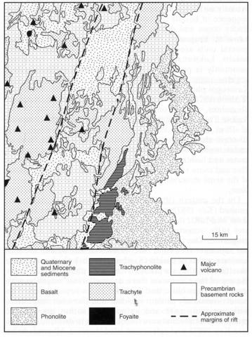
The Report by Key (1987b) of the Maralal degree sheet area includes the work of Baker (1963) in the northeastern sector and Shackleton (1946b) for the southeast. For the western half of the sheet Key’s description of the volcanic rocks incorporates the mapping of the EAGRU group (East African Geological Research Unit of London University), the geology being described in several unpublished PhD theses and illustrated by two full colour quarter degree geological maps. All this work is listed in Key (1987b) who indicates the principal igneous units that have been distinguished, puts them into stratigraphical context, and describes them systematically. The eastern third of the area is occupied by late Proterozoic to early Phanerozoic rocks of the Mozambique Orogenic Belt, that are concealed over the rest of the area beneath Miocene to Quaternary volcanic rocks and subsidiary sediments associated with the Gregory Rift. Three volcanic provinces are recognised, namely the western and eastern shoulders of the rift and the rift itself. The volcanic rocks include extensive lava plateau and the overlapping and interdigitating products of numerous central volcanoes. Individual volcanoes, which are particularly numerous on the western shoulder of the rift, are described separately. They include Kalokopon, Namarunu, Kailimerlim, Lomi, Kowun, Nasaken, Kapatagni, Kanatim, Kafkandal, Oliyamur, Emuruangogolak, Kajyamamuk, Kachila, Ribkwo and Silali (Nos 085-00-012 to 085-00-026). Some 26 volcanic stratigraphic units, including individual volcanoes, have been distinguished on the western shoulder and are each briefly described and summarised in Key (1987b, Table 7) and on the key of the accompanying map. These rocks extend westwards beyond the Maralal area into the Kalossia and Tiati areas (No. 085-00-010), which are described by Mason and Gibson (1957), but with much less detail. There are repeated cycles of flood basalt eruption and trachytic volcano building with extrusion of minor phonolitic and trachyphonolitic rocks, particularly within the volcanoes and to the west. The cumulative sequence of basalts is about 3200 m thick and erupted from cinder cones and dykes. They are alkaline and evolved to hawaiite, mugearite, basanite and trachyte although the general units are invariably named basalt e.g. Kapchererat basalts, Lokwanamur basalts etc. (Key, 1987). Analcime commonly is present in the basalts and katophorite and aegirine-augite may occur in the more evolved rocks. The Kasorogol phonolites, which occur in the extreme northwest of the area and are a northerly extension of the Kamasia phonolites, are the only phonolites of plateau type in the region. They are a little less than 100 m thick and comprise 12-15 m of welded and air full tuffs that are overlain by a 30-60 m thick flow which is followed by a further flow, of undetermined thickness, and finally by nine metres of agglomerates and bedded pumice tuffs. The main flow contains sanidine and more rarely nepheline phenocrysts in a groundmass of the same minerals, poikilitic amphibole and pools of analcime.On the eastern rift shoulder 16 volcanic units are distinguished (Key, 1987b, Tables 2 and 4) four of which are basaltic lavas and tuffs, the rest being trachytic and phonolitic lavas and tuffs, sometimes welded, trachyphonolites and rare mugearite. The total thickness is generally less than 2,000 m but adjacent to the rift it reaches 4,400 m. The base of the succession consists of basalts (Samburu basalts) which are mostly basaltic tuffs, that are always overlain by phonolites. Towards the top of the succession there is considerable variation with trachytic, phonolitic and basaltic rocks represented. The basalts commonly contain analcime and there are mugearites with aegirine-augite and katophorite within the basaltic groups. Phonolite units are too numerous to describe in detail (see Key, 1987b and references cited therein). Minerals to be found in the phonolites include nepheline, aegirine, aegirine-augite and augite, aenigmatite, brown amphibole (?katophorite, kaersutite), analcime, sodalite, fayalite and biotite. The trachytes vary from nepheline- to quartz-bearing types. They are invariably peralkaline generally with sodic pyroxene, sodic amphibole, often in mossy aggregates, commonly aenigmatite and, in some, sodalite.The volcanic rocks occurring within the rift are centred on three large, low angle shield volcanoes, the products of which are generally separated by fluviolacustrine sediments but locally overlap. The three volcanoes are described by Key (1987b) and even more comprehensively by Dunkley et al. (1993) who include numerous photographs in colour, with many spectacular ones taken from the air. These large volcanoes are described separately i.e. Namaranu (No. 085-00-013), Emuruangogolak (No. 085-00-022) and Silali (No. 085-00-026). Analyses are available for many rocks from this area a small selection of which are quoted by Key (1987b) who does, however, give a comprehensive list of the papers in which the chemical data are to be found.
DUNKLEY, P.N., SMITH, M., ALLEN, D.J. and DARLING, W.G. 1993. The geothermal activity and geology of the northern sector of the Kenya rift valley. British Geological Survey, Research Report. International Series SC/93/1: 1-185.KEY, R.M. 1987b. Geology of the Maralal area. Report, Geological Survey of Kenya, 105: 1-93. MASON, P. and GIBSON, A.B. 1957. Geology of the Kalossia-Tiati area. Report, Geological Survey of Kenya, 41: 1-34.SHACKLETON, R.M. 1946b. Geology of the country between Nanyuki and Maralal. Report, Geological Survey of Kenya, 11: 1-54.

