stripes
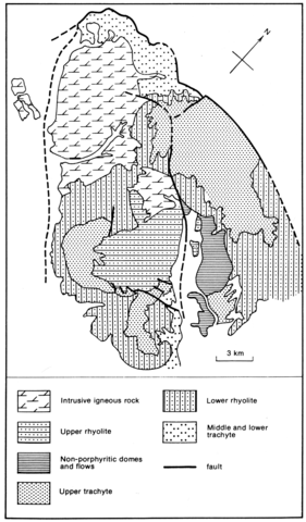
The Chinati Mountains are built essentially of volcanics which are centred on a large caldera of 30x20 km which contains a sequence of rhyolite and trachyte flows and tuffs more than 1000 m thick. The volcanics were intruded and tilted by the West Chinati stock of quartz monzodiorite and porphyritic hornblende granite. The volcanics within the caldera encompass an area of 450 km2 and the lowermost units, which are trachytic, lie on a basalt conglomerate. The sequence continues upwards into a rhyolite up to 450 m thick containing 1 cm diameter anorthoclase phenocrysts and a little biotite and aegirine-augite, which is followed by a trachyte similar to the lower trachytes. This is succeeded by an upper rhyolite which is a peralkaline lithic tuff with 20-25% anorthoclase phenocrysts, 10% quartz and 1% amphibole phenocrysts in a groundmass containing spherulitic aegirine aggregates. Xenoliths are numerous, 90% of which consist of a leucocratic rock with spongy aegirine masses. This unit is confined to an inner collapse zone and is thought to be an ash-flow tuff. There are a number of rhyolite domes and associated flows, while flow-banded rhyolitic dykes and plugs which intrude the upper trachyte and contain a blue sodic amphibole are probably related to the upper peralkaline rhyolite. The Mitchell Mesa rhyolite, which is a multiflow pyroclastic ash-flow deposit of comenditic composition occurring widely over the southern part of the Trans-Pecos volcanic field, erupted from the Chinati Mountains volcanic centre leading to the formation of the large caldera; a detailed coloured geological map of this is given by Cepeda and Henry (1983, Plate 1). Data on U and other trace elements are discussed by Cepeda et al. (1981).
CEPEDA, J.C. 1979. The Chinati Mountains caldera, Presidio County, Texas. In A.W. Walton and C.D. Henry (Eds). Cenozoic geology of the Trans-Pecos volcanic field of Texas. The University of Texas at Austin, Bureau of Economic Geology, Guidebook, 19: 106-25.
CEPEDA, J.C. and HENRY, C.D. 1983. Oligocene volcanism and multiple caldera formation in the Chinati Mountains, Presidio County, Texas. Report of Investigations, University of Texas at Austin, Bureau of Economic Geology, 135: 1-32.
CEPEDA, J.C., HENRY, C.D. and DUEX, T.W. 1981. Geology and uranium geochemistry of the Chinati Mountains caldera, Trans-Pecos, Texas. Studies in Geology, American Association of Petroleum Geologists, 13: 155-65.
MCANULTY, W.N. 1972. Mineral deposits in the West Chinati stock, Chinati Mountains, Presidio County, Texas. Geological Circular, University of Texas at Austin, Bureau of Economic Geology, 72-1: 1-13

