stripes
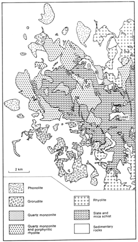
Situated on the northern side of the Black Hills, the Lead-Deadwood dome comprises a complex of intrusive igneous rocks covering 20x15 km. Many of the intrusions are laccolithic and were described in considerable detail by Jaggar (1901), but sills and dykes are also numerous. The principal rock types are rhyolites and rocks referred to as 'grorudites' by Paige (Darton and Paige, 1925, p. 16), which are peralkaline syenites and equivalent fine grained rocks; these two groups are concentrated in the central, southern and eastern parts of the area. Monzonites and quartz monzonites, which are mostly in the north, and phonolites/nepheline syenites form an outer ring of laccoliths on the northern and western sides of the dome. The silica-undersaturated rocks, grouped as phonolite and tinguaite by Paige (Darton and Paige, 1925, p. 16), carry alkali feldspar and sometimes aegirine-augite phenocrysts in a groundmass of alkali feldspar, aegirine, nepheline, sodalite, analcime and zeolites and sometimes biotite. They grade through aegirine trachytes to the grorodites which contain quartz, sometimes as phenocrysts, groundmass and phenocrystal alkali feldspar, ubiquitous aegirine and scarce biotite. A more precise petrographic account of these rocks is clearly required.
DARTON, N.H. and PAIGE, S. 1925. Central Black Hills Folio: South Dakota. Geologic Atlas of the United States: 219.
JAGGER, T.A. 1901. The laccoliths of the Black Hills. Annual Report, United States Geological Survey, 21(3): 163-290.
LISENBEE, A. KARNER, F., FASHBAUGH, E., HALVORSON, D., O'TOOLE, F., WHITE, S., WILKINSON, M. and KIRCHENER, J. 1981. Geology of the Tertiary intrusive province of the Northern Black Hills, South Dakota and Wyoming. In F.J. Rich (Ed.). Geology of the Black Hills, South Dakota and Wyoming. American Geological Institute, Field Trip Guidebook: 33-105.
MCDOWELL, F.W. 1971. K-Ar ages of igneous rocks from the western United States. Isochron/West, New Mexico Bureau of Mines and Mineral Resources, 2: 1-16

