stripes
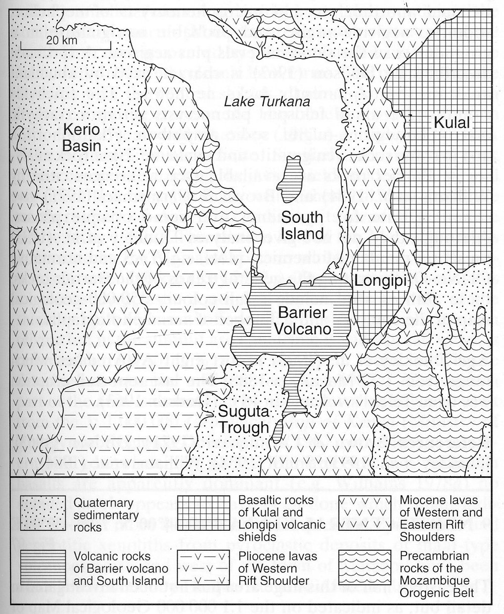
This large area extends around the southern reaches of Lake Turkana and includes numerous volcanic fields and centres many of which, but not all, are alkaline. Ochieng’ et al. (1988) recognise 14 major volcanic sequences including five units on the western shoulder of the rift valley, six on the eastern shoulder and three within the rift. West of the volcanic rocks on the western shoulder of the rift a sequence of Quaternary sediments occupying the Kerio Basin are followed westwards by more volcanic rocks and associated intrusions that form the Napedet and Kamutile Hills which merge with the western rift shoulder volcanics in the south of the area (Dodson, 1971; Joubert, 1966). Kulal is a large basaltic shield volcano extending northeastwards beyond the area and Longipi a smaller basaltic shield. The Barrier volcano, lying within the rift at the southern end of Lake Turkana, represents the youngest volcanic activity in the region and is described separately (No. 085-00-08), while South Island at the southern end of the lake is a further volcanic centre. Many of the volcanic rocks of the area are of ‘plateau’ type and so emanated from numerous small centres or cannot be traced to a single source. Detailed accounts of the relative ages and stratigraphic relationships of the various volcanic units are given in the cited references. The rocks of the western rift shoulder comprise an older series further west and a younger series, forming the extensive Loriu Plateau, immediately adjacent to the rift, which is marked by a fault scarp more than 360 m high. Three major volcanic units comprise the older series (Ochieng’ et al., 1988): the basal Chibelet basalts, the Emuruabwin phonolites and the uppermost Kaling basalts. The Chibelet basalts contain a little olivine, commonly analcime, sometimes biotite and possible aenigmatite, while nepheline is also present in the Kaling series so that both are esssentially basanites. The Emuruabwin series includes phonolitic lavas and tuffs, nephelinites, tephrites and basaltic andesites with equivalent dykes and small plugs. The phonolites commonly contain glomeroporphyritic clusters of nepheline and sanidine in a groundmass of aegirine-augite, sanidine and aenigmatite; analcime and an amphibole have been reported. Nephelinites consist of aegirine or augite, nepheline, partly replaced by sodalite, and an opaque phase in a groundmass of the same minerals plus titanite and in some rocks secondary calcite and zeolite. Tephrites comprise augite, rare brown amphibole, plagioclase (An40-55) with nepheline in the groundmass. The Loriu Plateau is dominated by basalts, basanites, hawaiites and minor phonolites which are cut by dykes of basanite and trachyte. There are several eruptive centres of trachyphonolitic pyroclastic rocks and lavas with foyaite at some centres. The rocks of the eastern rift shoulder extend north-south the full length of the map area and include the major volcanoes of Kulal and Longipi. Lava flows predominate and are cut by numerous north-south-trending faults. These rocks are mainly olivine basalt but there is subordinate rhyolite and trachyte, the latter forming flows and a plug. Although the rhyolites are said to contain ferromagnesian minerals, including amphibole (Dodson, 1963), these are generally altered so it is not clear if they are alkaline. Similarly, the mineralogy of the trachytes is generally obscured by alteration but trachytes of the same series (the Tirr Tirr series) described from the map sheet to the south contain microphenocrysts of aegirine (Baker, 1963a). The ‘within rift’ units include the Barrier volcano (No. 085-00-08), South Island in Lake Turkana and an area of volcanic rocks in the north of the area close to the eastern shore of the lake. The southernmost part of the rift forms the Saguta Trough of Quaternary sediments and some basaltic lava flows. South Island is a basaltic volcano of flows, cinder cones and ash beds. The volcanic rocks adjacent to the lake in the north represent the most southerly extension of the Jarigole volcanics, which are much more extensive in the Allia Bay area to the north (No. 085-00-02), to which reference should be made for a fuller description (Wilkinson, 1988). They include phonolite, nephelinite and tephrite and a description of these rocks for the Loiyangalani area will be found in Ochieng’ et al. (1988). There are few major intrusions in the area but Kapel Tukei in the west is a nepheline syenite plug 2 km in diameter. It intrudes Chibelet basalts and consists of sanidine, aegirine - aegirine-augite, nepheline, analcime and in some varieties aenigmatite. Phonolitic dykes are reported from many parts of the region.The igneous rocks in the extreme west of the area are described in the reports, and accompanying maps, for the area south of Lodwar (Dodson, 1971) and the Loperot area (Joubert, 1966). Olivine and analcime basalts and trachybasalt are the most voluminous volcanic rocks but there are also extensive phonolites and phonolitic trachytes, particularly in the north, which cap hills of basalt. The phonolites generally contain phenocrysts of alkali feldspar and, more rarely, nepheline in a base of mossy aegirine and aenigmatite and usually analcime. Intrusions of microfoyaite are numerous, the largest being the 4x3 km Lokhoriokhot intrusion, and swarms of microfoyaite and fewer nephelinite dykes occur, particularly in the north of the area,. The microfoyaite consists of aligned alkali feldspar prisms, nepheline, aegirine and/or aegirine-augite, analcime and rarely a brown amphibole. The nephelinite generally contains phenocrysts of nepheline, in one dyke up to 9 mm in length, and aegirine-augite (Dodson, 1971); the matrix consists of nepheline, pyroxene and an opaque phase.
BAKER, B.H. 1963a. Geology of the Baragoi area. Report, Geological Survey of Kenya, 53: 1-74.DODSON, R.G. 1963. Geology of the South Horr area. Report, Geological Survey of Kenya, 60: 1-53.DODSON, R.G. 1971. Geology of the area south of Lodwar. Report, Geological Survey of Kenya, 87: 1-36.JOUBERT, P. 1966. Geology of the Loperot area. Report, Geological Survey of Kenya, 74: 1-52.OCHIENG’, J.O., WILKINSON, A.F., KAGASI, J. and KIMOMO, S. 1988. Geology of the Loiyangalani area. Report, Geological Survey of Kenya, 107: 1-53.WILKINSON, A.F. 1988. Geology of the Allia Bay area. Report, Geological Survey of Kenya, 109: 1-54.