stripes
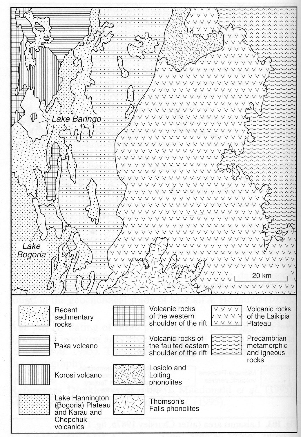
Running approximately north-south in the western part of this one degree square area is a complete segment of the East African (Gregory) Rift within which lie lakes Baringo and Bogoria (formerly Lake Hannington). The area is underlain by early to late Proterozoic metamorphic rocks of the Mozambique Orogenic Belt, which only outcrop in a narrow strip along the eastern margin. Most of the area is occupied by Miocene to Recent volcanic rocks which include two large volcanoes within the rift but are predominantly ‘plateau’ extrusive rocks mantling the rift shoulders. The area is described in detail by Hackman (1988) and the northeastern part is covered by one of the 1:125,000 geological maps of the E.A.G.R.U. project (Truckle, 1977), while the southwestern quarter is described by McCall (1967) with an accompanying 1:125,000 scale map. The volcanic rocks can be divided spatially into four major groups i.e. the western shoulder of the rift, the faulted eastern shoulder, the Laikipia Plateau and the rift valley. The western rift shoulder covers only a small part of this area, being much more fully represented in the area to the west (No. 085-00-031). Areas of Pliocene basalt are present but Quaternary volcanic rocks include trachyte and trachyphonolite, as well as basalt. The Loyamarok trachyphonolite extends for 30 kilometres along the western boundary of the degree sheet area and appears to be a single flow up to 90 m thick. Much of the flow has a partially devitrified ignimbritic carapace which forms a sheet up to 1 m thick of glass enclosing flattened lava fragments. It contains 7-15% nepheline microphenocrysts with rarer sanidine; katophorite, aenigmatite, analcime and natrolite have been observed together with aegirine-augite, which often forms rims to nepheline. The Baringo trachyte, lying immediately west of the lake, is a flow up to 60 m thick comprising up to 60% sanidine, aegirine-augite, aenigmatite and zeolites. The volcanic rocks of the faulted eastern shoulder of the rift occupy a zone up to some 25 km wide, range from Miocene to Pleistocene in age and include basalts, mugearites, trachytes, trachyphonolites and phonolites (Hackman, 1988, Table 2). Miocene units distinguished include the Sabit trachyte (typically eutaxitic), the Murgomul volcanics (hawaiite, trachyphonolite and ignimbrites including phonolitic welded tuff), the Lopet phonolites (mainly trachyphonolites but including mugearites and trachytes), the Katomuk tuffs (phonolitic ignimbrites), the Komol volcanics (olivine basalt, hawaiite, mugearite, phonolite and trachyte), the Alengerr tuffs (ignimbrites, trachyphonolites and some basalt and mugearite) and the Tasiokwank phonolitic trachytes. Volcanic rocks of Pliocene age within the eastern rift shoulder include small areas of alkali olivine basalt and extensive outcrops of the Orus trachyte. Pleistocene rocks include several distinct basalt units, the Chepchuk volcanics, which include peralkaline quartz trachytes and less basalt, the whole comprising the eastern half of a volcano, the western half of which was down-faulted towards the rift and covered by younger volcanic rocks, the Karau volcanics, which erupted from three volcanic centres and comprise essentially trachyphonolites (flows, pumice and welded tuffs) and the Mukutan and Mistoni mugearites. Almost all of the trachytic and phonolitic rocks of the eastern rift shoulder are peralkaline, containing various combinations of alkali pyroxene, amphibole and aenigmatite. Nepheline is the principal feldspathoid but sodalite is also reported. The Murgomul plug is about 1 km across and cuts Samburu basalts in the northern part of the faulted eastern shoulder. It comprises an outer analcime hawaiite, inside which is a ring of nepheline syenite and syenodiorite with a central plug of coarse analcime foyaite (Hackman, 1988). Four phonolite intrusions are located just north of the Murgomul plug.The Laikipia plateau is a monotonous volcanic area that extends for about 50 km eastwards from the inner rift shoulder, where it is bounded by spectacular escarpments, to the contact with the basement metamorphic rocks. Most of the plateau is covered with phonolites of Miocene age the various units of which are given the portmanteau term of Rumuruti Group by Hackman (1988), who describes in some detail the nomenclatural complexity of these rocks. They everywhere rest unconformably on Samburu basalts and generally form flows but some air fall tuffs are also part of the sequence in places. Phenocrysts of alkali feldspar and nepheline, and in some units biotite and alkali pyroxene, are usual and set in a groundmass generally containing alkali pyroxene and amphibole. Other formations on the Laikipia plateau are the Sipili trachytes, which have phenocrysts of alkali feldspar and microphenocrysts of fayalite in a groundmass that may include biotite, hornblende, katophorite, aenigmatite, aegirine-augite and analcime, the Losiolo and Loiting phonolites and the Thomson’s Falls phonolites, phonolitic trachytes and trachytic tuffs, named after a spectacular 65 m high waterfall over a single phonolite flow. All of these rocks contain a range of sodic mafic minerals reflecting their peralkalinity.The northern part of the rift is dominated by the central volcanoes of Paka and Korosi, which are described individually (Nos 085-00-033 and 085-00-034), but the southern part of the rift is occupied by Pleistocene flood lavas and some tuffs. They include basalts, hawaiites, mugearites, the Hannington trachyphonolites, which are up to 300 m thick and include some trachytes and phonolites with subordinate agglomerates and tuffs, and the Jorokokwa phonolites. Many rock analyses have been made and will be found in the theses and reports cited by Hackman (1988); a detailed geochemical study of the Hannington phonolites, including REE data, is that of Griffiths and Gibson (1980).
GRIFFITHS, P.S. and GIBSON, I.L. 1980. The geology and petrology of the Hannington trachyphonolite formation. Lithos, 13: 43-53.HACKMAN, B.D. 1988. The geology of the Baringo-Laikipia area. Report, Geological Survey of Kenya, 104: 1-47.MCCALL, G.J.H. 1967. Geology of the Nakuru - Thomson’s Falls - Lake Hannington area. Report, Geological Survey of Kenya, 78: 1-122.TRUCKLE, P.H. (compiler) 1977. Geological map of the Lake Baringo-Laikipia area (Scale 1:125,000). Directorate of Overseas Surveys, Ordnance Survey, East African Geological Research Unit, Kenya Rift Valley Project.