stripes
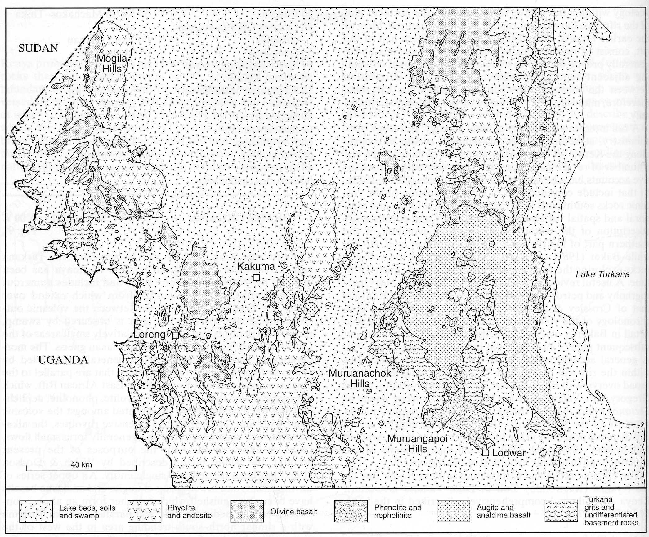
The vast area lying north of 3°00’N between Lake Turkana and the northern and western borders of Kenya has been mapped by Walsh and Dodson (1969) and includes numerous volcanic centres, the oupourings from which extend over about one third of the total area. Between the volcanic outcrops the greater part of the area is obscured by swamp, recent lake deposits and soils with relatively small areas of the Lower Tertiary Turkana Grits and Archaean gneiss. The morphology of the volcanic edifices is generally controlled by systems of north-south-trending faults, that are parallel to the northernmost section in Kenya of the East African Rift, which lies east of Lake Turkana. Basalt, rhyolite, phonolite, nephelinite and trachyandesite are represented amongst the volcanic successions but, apart from the extensive rhyolites, the alkaline rocks are widely scattered and generally form small flows, plugs or dykes so that, for the purposes of the present account, the whole region described by Walsh and Dodson (1969) has been treated as a single entity. An upper series of olivine basalts and lower group of augite and analcime basalts have been distinguished which together form an almost continuous belt immediately west and parallel to Lake Turkana with a similar north-south-trending area in the west of the region. The basalts all appear to be alkaline, and some are basanitic, a few samples of which are described by Smith (1938). The more strongly alkaline rocks of the area include phonolite, phonolitic agglomerate, nephelinite, olivine nephelinite and microfoyaite, generally as flows but there are some plugs and dykes. The largest concentration is in the Muruangapoi Hills immediately north of Lodwar. A typical phonolite from this area (Walsh and Dodson, 1969) consists of rare microphenocrysts of nepheline, partly replaced by sodalite, and anorthoclase in a matrix of aegirine-augite, anorthoclase and nepheline. A nephelinite in the Muruangapoi Hills contains abundant augite phenocrysts up to 1 cm in length and fewer of sodalite pseudomorphing nepheline in a groundmass of nepheline, sodalite, aegirine-augite and a little titanite and magnetite; amygdales consist of stilbite. Nephelinite also forms the prominent Lodwar Cone (Walsh and Dodson, 1969, Plate 1a), and has phenocrysts of green-rimmed titanaugite, red to orange poikilitic phlogopite, titanite and magnetite in a groundmass of euhedral nepheline, green pyroxene and magnetite. Specimens of this rock were said by Smith (1938) to “provide some of the best examples of nephelinites I have ever seen.” ; a full page drawing will be found in Hatch et al. (1972). A nephelinite flow also occurs southeast of the Muruanachok Hills. A rock from within Lodwar itself is a tephrite (Smith, 1938; Walsh and Dodson, 1969) comprising abundant phenocrysts of andesine and fewer of probable kaersutite in a groundmass of orthoclase, aegirine-augite, magnetite and probable nepheline. About a dozen phonolite plugs, some with associated flows, occur amongst and cut the large area of basalts to the north of Lodwar. These rocks comprise orthoclase, nepheline and aegirine-augite with in some varieties riebeckite and aenigmatite. A riebeckite-bearing phonolite flow occurs at Muruanachok, about 50 km northwest of Lodwar. A coarse phonolite, which might be a sill, outcrops along the southeastern margin of the Mogila Hills, in the northwest of the region; the rock contains feldspar phenocrysts and aegirine-augite, riebeckite and a little nepheline in the groundmass. There are also phonolites, probably forming plugs, southeast of Kakuma and east of Loreng. Rhyolites are even more extensive than basalts in the North Turkana area and cap all the major mountain ranges except in the southeastern part. The rhyolites are often, according to Walsh and Dodson (1969), of pyroclastic origin but no modern work appears to have been done to determine the exact nature of these rocks, although some at least are probably ignimbrites. Many of the rhyolites are altered but fresher specimens reveal the presence of sanidine, and sometimes quartz, phenocrysts and variably katophorite, riebeckite and aenigmatite. These rocks are described in some detail by Smith (1938) who identifies them as comendites while a series with less abundant quartz and one, or sometimes two, types of blue sodic amphibole, he refers to as pantelleritic trachyte. A swarm of teschenitic dykes, including rocks referred to as essexite and berondrite (see Smith, 1938), occurs in the northern part of the Labur Range, which lies just west of Lake Turkana close to the Sudanese border. These rocks consist of plagioclase, augite, much magnetite, hornblende, biotite, interstitial analcime and, rarely, altered nepheline. In the Muruanachok area there is an extensive swarm of phonolitic dykes and two phonolite ring dykes; these rocks commonly contain a sodic amphibole and aenigmatite. Other minor occurrences are detailed by Walsh and Dodson (1969). Apart from single analyses of basalt and phonolite, quoted by Walsh and Dodson (1969), there appear to be no chemical data for the igneous rocks of the area.
HATCH, F.H., WELLS, A.K. and WELLS, M.K. 1972. Petrology of the igneous rocks (13 th Edition). Thomas Murby, London. 551 pp.SMITH, W. C. 1938. Petrographic description of volcanic rocks from Turkana, Kenya Colony, with notes on their field occurrence from the manuscript of Mr. A.M. Champion. Quarterly Journal of the Geological Society of London, 94: 507-53.WALSH, J. and DODSON, R.G. 1969. Geology of Northern Turkana. Report, Geological Survey of Kenya, 82: 1-42.ZANETTIN, B., VISENTIN, E.J., BELLIENI, G., PICCIRILLO, E.M. and RITA, F. 1983. Le volcanisme du Bassin du Nord-Turkana (Kenya): age, succession et evolution stucturale. Bulletin des Centres de Recherches Exploration-Production Elf-Aquitaine, 7: 249-55.